Design
National Sign Plaza’s Wayfinding Approach
Company President Grant Hayzlett Explains Methodology
Published
10 years agoon
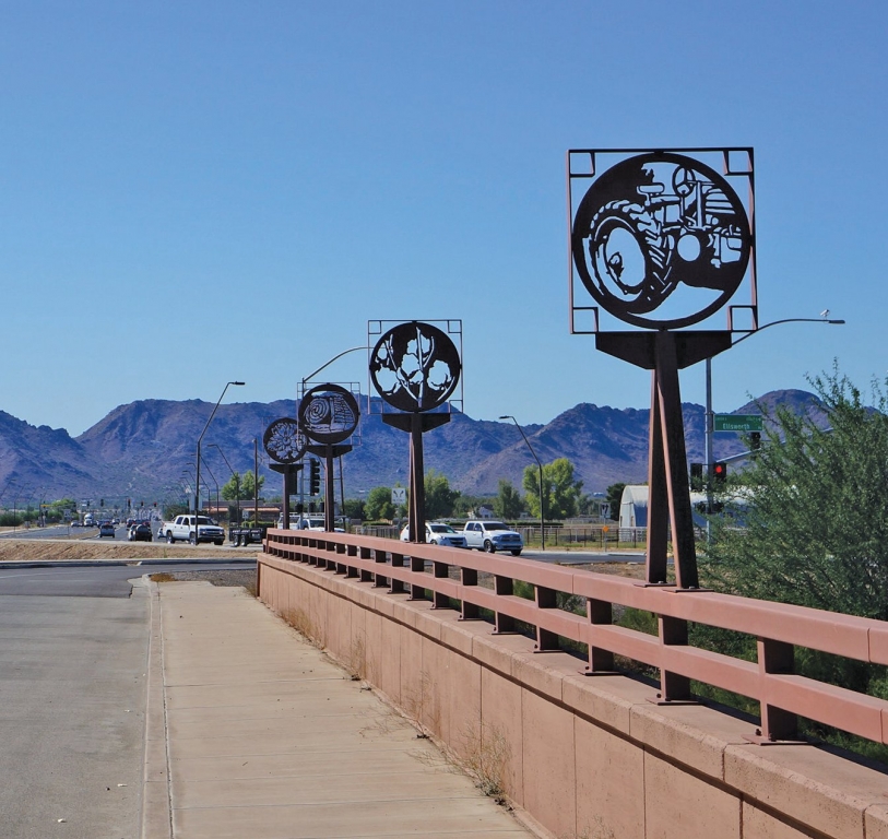
Driving the primary thoroughfares of almost any city, no matter its population, geography or density, will provide a strong indication that wayfinding has transcended the reflective-film-on-green-paint, utilitarian Dept. of Transportation (DOT) signs of generations ago. Now, thanks to Google Alerts, scarcely a day goes by without news about another municipality exploring the development of a civic-wayfinding program, soliciting bids or announcing completion of a project phase.
Years of economic doldrums and pessimism have at last given way to hope and, more tangibly, progress and development. So, cities are exploring prudent investment to enhance their qualities of life. While enticing visitors, prospective new residents and corporate facilities with such amenities as new or revamped roads, schools and other infrastructure upgrades is certainly essential, the young professionals cities clamor to attract expect their community to be progressive and dynamic, with everything necessary for their pursuit of happiness.
Signage provides that initial point of contact that establishes a city’s personality. Like a handshake, it can command your attention and leave a favorable impression, or it can linger like a limp fish and leave the recipient itching to move on.
For 17 years, National Sign Plazas (NSP), which is headquartered in Denver and maintains nine nationwide offices, has developed wayfinding programs almost exclusively for governmental clients. Grant Hayzlett, the company’s president, offers his insights on the evolution of wayfinding signage and what trends primarily impact the environmental-graphics market.
During NSP’s 17 years in business, how has the wayfinding design and execution process changed the most?
The great change in wayfinding design and planning is the platform of application for signage and public art. Historically, environmental graphics (wayfinding, public art, branded environments, etc.) were relegated to dense urban platforms – major cities with broad economic-development and tourism goals. Now, with a more global economy, mid-sized and even small, suburban areas pay more attention to civic branding and destination marketing. Lacking big-city budgets, these smaller cities are more diligent in creating clearly defined systems that require a more defined return on investment. Also, there’s more community involvement and project oversight with programs in smaller communities.
How do you find your work?
I estimate we gain one-third of our business by word-of-mouth reference from existing clients. The municipal-government community tends to be close-knit within each state, and an endorsement from someone with a positive experience carries some weight. We gain another third through educational outreach (tradeshows, webinars, etc.); these customers have already identified the need for wayfinding, but may need some guidance regarding best practices. The remaining third comes from outreach directly to governments. This process requires a great deal of due diligence on our part because wayfinding can address a wide variety of civic branding and economic development. Often, we have to illustrate their needs before we can demonstrate our capabilities.
Do you approach most of your projects from a design/build perspective?
We approach projects from our design/plan/build platform. That being said, we can’t always contact clients in a developmental stage early enough to manage an entire project. And, some civic budgets don’t allow for clients to completely fund a project, and they need to approach the design and/or planning process without an immediate transition to fabrication and installation. Approximately 70% of our clients have used our complete services, which includes ongoing management; 20% use design and planning without fabrication, and 10% fabrication and installation only.
As a general rule, we don’t work with other design teams. We have developed fabrication and installed projects based on other design plans, but those firms are seldom involved with projects once the construction phase begins.
With what entities and organizations do you work on wayfinding projects? In addition to DOT and city planning departments, are design-review boards, historical societies and other organizations frequently involved?
Consultancy involves working with an array of city staff, community representatives and other consultants working on projects tangential to ours. Projects often begin with interactions with community-development or planning departments, and other city departments provide input as needed. By the time a project kicks off, the group inevitably grows to include the local chamber of commerce, convention and visitors’ bureau, and representatives from neighborhoods directly impacted by a wayfinding system’s implementation.
Although it’s impossible to define a standard collaborative group for a wayfinding system, it’s become more common for us to engage in some level of community outreach as we design and develop wayfinding projects. Community feedback isn’t always positive – some people question the need for a wayfinding system, or any government expenditure at all – but it’s our job as consultants to listen and incorporate feedback into our planning and design when it’s appropriate. After all, projects must be considerate of the needs of many.
Why do you find the design/build model preferable?
We developed our design/plan/build wayfinding model based on the waste and inefficiencies that arise when a city or county is required to break a wayfinding project into multiple, unnecessary steps. We’ve found that, because designers aren’t obligated to build their own designs, they’re sometimes inconsiderate of the cost to build signage and environmental graphics.
Because wayfinding design and planning ultimately renders a wayfinding system, I think it makes no sense to separate the functions of design and construction. Giving one project facet priority over another creates inefficiencies, and requires the city or county to continually search for qualified vendors.
Research, review and discussions about funding and feasibility require an astounding amount of time, and repeating the process drains even more time and resources. A design firm that isn’t involved with the fabrication process doesn’t have to concern itself with the client’s budget because they’re not providing billable services after their phase is complete. Conversely, a fabricator that doesn’t design has little exposure to or understanding of the social and developmental dynamics of environmental design. A successful wayfinding and civic-branding design requires an interconnected, comprehensive process.
How is the scope of a project dictated? What is your typical project timeline?
NSP develops the scope during the planning stage, which involves taking input from the community about the system goals, along with other planning objectives and economic-development initiatives. In some cases, a vehicle system alone can convey the required information about places and destinations. However, pedestrian-oriented signage is usually needed.
First, we place ourselves as visitors would view the area. People think of wayfinding as only directional signage, but it’s so much more. Consider how healthy-living initiatives and other efforts that promote overall public wellness can influence the information conveyed in a pedestrian-sign program. We need to not only direct traffic, but educate users. There’s a nationwide movement toward more walkable communities, and environmental graphics should reflect this when appropriate.
Do you have a formula for the number of signs an area’s wayfinding program should incorporate?
The total number of signs a program requires is usually mandated by the geography of a city or county. There’s a connection between a city’s geographic size and the signs needed, but only because larger cities require more signs. Wayfinding and branded environments can sometimes be applied to a specific area without filtering through the citywide program. The density or program destinations will also impact sign placement.
It’s difficult to develop a vehicular-wayfinding design that accommodates more than five destinations without compromising safety and legibility. The alternative is to drive traffic to a common area, and then let pedestrian wayfinding and other environmental graphics take over.
What factors influence design components?
The development of content (logos, color schemes, fonts, destinations, etc.) is handled in a two-step process. First, the client informs us of their design goals. Often this is dictated by honoring historic features or increasing the visibility of new ones. Every client of ours has a predefined idea of what they think looks good and what they think doesn’t and we have to learn those parameters in order to develop a successful design. The next step is for to take all of the ideas that have been provided and developed project themes. These thematic designs honor the ideas that the client has presented without building a literal interpretation. Further, the design themes will be carried over in to the different features and sign types of the system to reinforce to the user that they are all part of the greater system.
How does a wayfinding program successfully transition from vehicular to pedestrian mode?
Each wayfinding system presents a unique transition between modalities. A common example would be directing vehicular traffic into a parking area, and then picking up pedestrian signage as users exit the garage lot. However, this transition can be more complex: consider a rail/bus stop that allows cyclists to park their bikes and board. They will require different information, and be looking for directions unique to their transition. A detailed system may require specific strategies for pedestrians, cyclists and motorists, with each component tying into the overall goal of comprehensive wayfinding.
How do DOT standards influence wayfinding systems?
Many state DOTs have defined a process for cities to gain approval for civic-wayfinding systems to be placed in road rights-of-way. In states that have a defined approval process, many factors must be considered when applying. Because the DOT’s primary function is driver safety, you can’t inhibit state-level directional signs for aesthetics, no matter how redundant. However, many states will allow you to remove or replace state signage if the information is incorporated into new signage. Working with DOTs requires an intimate relationship with the local engineer, especially if they’ve not established clear approval processes.
How do you determine materials used for your signs’ fabrication?
Material analysis is part of the design process. We don’t stock anything or produce off-the-shelf designs. We constantly try to increase our knowledge of new materials and methods to execute creative designs, while staying on budget. Anodized metals and powdercoatings are important components because they help us achieve unique looks without having to source hard-to-find materials. We also like to incorporate industrial materials, such as aluminum screens, which allow us to differentiate otherwise common designs. The surrounding environment, landscaping, existing architecture and civic amenities all influence the materials and finishes we specify in our construction documents.
SPONSORED VIDEO
Introducing the Sign Industry Podcast
The Sign Industry Podcast is a platform for every sign person out there — from the old-timers who bent neon and hand-lettered boats to those venturing into new technologies — we want to get their stories out for everyone to hear. Come join us and listen to stories, learn tricks or techniques, and get insights of what’s to come. We are the world’s second oldest profession. The folks who started the world’s oldest profession needed a sign.
You may like


Advertisement
Subscribe

Magazine
Get the most important news
and business ideas from Signsofthetimes Magazine.
Advertisement
Most Popular
-

 Tip Sheet1 week ago
Always Brand Yourself and Wear Fewer Hats — Two of April’s Sign Tips
-

 Photo Gallery3 days ago
30 Snapshots of the 2024 ISA Sign Expo
-

 Ask Signs of the Times5 days ago
Why Are Signs from Canva so Overloaded and Similar?
-

 Real Deal2 weeks ago
A Woman Sign Company Owner Confronts a Sexist Wholesaler
-
 Benchmarks1 week ago
6 Sports Venue Signs Deserving a Standing Ovation
-

 Paula Fargo11 hours ago
5 Reasons to Sell a Sign Company Plus 6 Options
-

 Photo Gallery12 hours ago
21 Larry Albright Plasma Globes, Crackle Tubes and More
-

 Women in Signs2 weeks ago
2024 Women in Signs: Megan Bradley